Physical and Urban Environments
by Risha Balakrishnan
Concepts and Terminology
Insula: A block of buildings, surrounded by streets on all sides. The plural of insula is insulae.
Villa Rustica: Country farm /farm house
Villa Suburbana: House in the city
Villa Maritima: Seaside house of some luxury.
Villa Rustica: Country farm /farm house
Villa Suburbana: House in the city
Villa Maritima: Seaside house of some luxury.
Geographical setting of Campania(the region being home to both Pompeii and Herculaneum)
- Around 200km south of Rome
- Located along he Bay of Naples (Modern day Italy)
COASTAL TOWNS
- Contains both Pompeii and Herculaneum
- Both Pompeii and Herculaneum are located along the Bay of Naples, Herculaneum moreso.
- Mount Vesuvius, at 1300 metres, is a dormant volcano that is centre of both Pompeii and Herculaneum
- Herculaneum is 7km west of Vesuvius
- Pompeii is 10km south of Vesuvius
- Other cities in the region: Stabiae, Surentum and Mycenum
- Mt Vesuvius was a part of a chain of volcanoes that stretched from Tuscany through to Sicily.
o The region was subject to seismic activities
§ Thermal springs
§ Rising and sinking of coastlines
§ Periodic earth tremors
Natural Features
- Mt Vesuvius
- Due to being located around a volcanic region, Pompeii and Herculaneum had very fertile land.
- Temperate climate
- River Sarno flows through the region from east to west and into the bay.
- Appenine mountains
- Due to being located around a volcanic region, Pompeii and Herculaneum had very fertile land.
- Temperate climate
- River Sarno flows through the region from east to west and into the bay.
- Appenine mountains
Natural Resources:
- Olives
- Grapes
- Clay
- Wheat
- Barley
- Sand and lime - gave local cement
- Sheep and goats - Milk, meat, skins and wool
- Fruits and vegetables
- Rich marine resources - Consumption as well as production of garum sauce, thriving fish & shellfish industry
- Fertile soil - Gave crops two to three times a year
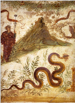
Fresco of Bacchus (God of wine) standing beside Mount Vesuvius.
This fresco demonstrates the fertility of the region. Bacchus covered in grapes implicates that wine was a major factor in the region. Trees indicate the fertility of the land
This fresco demonstrates the fertility of the region. Bacchus covered in grapes implicates that wine was a major factor in the region. Trees indicate the fertility of the land
Urban Landscape and Features
Both Pompeii and Herculaneum’s streets were laid out on a grid system.
The man axial roads (decumani) crossed by minor roads (cardini) created blocks (insulae). Each insulae was around 35mx90m
Both cities had fortified walls. Pompeii’s wall seemingly greater than that of Herculaneum.
Sidewalks were elevated.
Wheel ruts from vehicles are still noticeable nowadays.
Pompeii:
64 hectares in area
Pompeii’s city wall was 3.2km, and tended to follow the more defensive line of landscape
The city could be accessed by eight gates, five of which led to other cities in the Campanian region
(The eight gates along the Pompeiian wall were the gates of Herculaneum, Vesuvius, Capuan, Nolan, Sarno, Nucerian, Marine and Stabian gates).
Over time, the gates especially that of the Vesuvius gate became more elaborate in decoration, implicating that defence was less important during the time of the eruption.
Pompeii had stepping stones that had a dual function for transporting civilians from one side to another (due to garbage that lurked on the roads) as well as helping to keep chariots in line with the road, so that they would not veer off course.
Fountains at many intersections
Fountains were given water by lead pipes running underneath the pavement at two cisterns by the Vesuvius Gate and Forum baths.
Main streets were the:
Via Stabiana (uneven, ran from NW to SE on a steep lava slope) &
Via dell’Abbondanza (street of plenty, given its name by Giuseppe Fiorelli)
Pompeii’s main road, at its full width was 8.5metres. Other roads varied from 3.5-4.5 metres in width, but many were not wide enough for two way traffic.
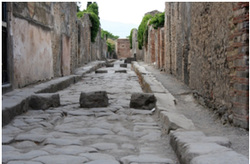
Pompeiian stepping stones.
This shows the regular stepping stones that were found in the streets of Pompeii. It implicates that these were used to keep chariots in line and that civilians had used them too. Notice the wheel ruts from vehicles that are shown in-between the stepping stones.
This shows the regular stepping stones that were found in the streets of Pompeii. It implicates that these were used to keep chariots in line and that civilians had used them too. Notice the wheel ruts from vehicles that are shown in-between the stepping stones.
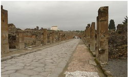
Via dell’Abbondanza- the main street in Pompeii.
Herculaneum:
Around 22 hectares (could be larger as access to uncover Herculaneum is limited)
Herculaneum’s city wall modest compared to Pompeii’s.
Due to most of Herculaneum being buried under the modern town of Ercolano in Italy, evidence is limited,
Part of Herculaneum’s main road, the Decumanus Maximus was uncovered, at an overwhelming 12metres. There was very little traffic, as vehicles were banned from this road.
Expansion of Herculaneum was limited due to its proximity to the sea.
Drainage was better than that of Pompeii. Had a large well constructed underground sewer, which ran beneath the roads and into the sea.
This prevented streets from being waterlogged with garbage and excretion. So unlike Pompeii, Herculaneum did not have any use for stepping stones.
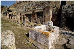
Picture Above:
Public fountain at Herculaneum. The site can be recognised as Herculaneum due to the lack of stepping stones. The lack of stepping stones can not only implicate a better developed sewerage system (as explained) but can also implicate that there was less traffic as opposed to Herculaneum, as stones were seen to help align chariots.
Written Ancient Sources:
Florus, ‘Epitome’ = Here, Florus discusses the region of Campania, taking note of its seas, famed harbours and most of all, its fertile land.
“Of everything not just in Italy, but in the whole world, the region of Campania is the most beautiful. Nothing more temperate than its climate: indeed, its spring flowers blossom twice. Nothing is more fertile than its land: consequently there is said to be a competition between Liber and Ceres. Nothing is more welcoming than its sea: here are those famous harbours of Caieta, Misenum and Baiae with its warm springs, the Lucrine Lake and Avernus, some of the pleasures of the sea. Here are the mountains which befriend the vine-. Garus, Falernus, Massicus, and the most beautiful of them all, Vesuvius, imitator of Etna’s fire. Here are the coastal cities of Formiae, Cumae, Puetoli, Naples, Herculaneum, Pompeii and that chief of cities, Capua, once reckoned among the three greatest”
Pliny the Elder = Pliny the Elder’s description of Campania further demonstrates its fertile land and the use of its natural resources. He describes the region as being so abundant with nature, producing plenty of fine crop and resources, such as ‘the splendid fleeces’ of sheep to the ‘rich sources of rivers’.
“How am I to describe the coast of Campania. A fertile region so blessed with pleasant scenery that it was manifestly the work of nature in a happy mood? Then indeed there is that wonderful and life-sustaining and healthy atmosphere that lasts all the year through. Embracing a climate so mild, plains so fertile, hills so sunny, woodlands so secure and groves so shady. Campania has a wealth of different kinds of forest. Breezes from many mountains, an abundance of corn, vines and olives, splendid fleeces produced by its sheep, fine-necked bulls, numerous lakes, rich sources of rivers and springs that flow over the whole region. Its many seas and harbours and the bosom of its lands are open to commerce. While even the land eagerly runs out into the sea as if to assist mankind”
Tacitus describing the Bay of Naples = In this excerpt, Tacitus describes the Bay of Naples, post eruption. From this, it can be deducted that the Bay of Naples had changed in appearance after the eruption, to a site less favourable in appearance than what is was before the eruption. However, his statement also further proves that the Bay of Naples was a beautiful place, implicating that Campania was not only fertile, but had incredibly beautiful scenery.
“...A most beautiful bay—beautiful that is, before the eruption of Vesuvius changed the landscape”
Archaeological sources
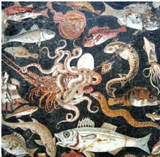
This mosaic from Pompeii shows marine life. Such a mosaic demonstrates the marine life found in Pompeii thus showing that marine life was most likely a natural resource in Pompeii.
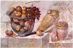
Like the mosaic of marine life, this fresco of fruit demonstrates that fruit was found in Pompeii, and was most likely grown in the region. Especially that of grapes, and apples.
Secondary Sources
Andrew Wallace-Hadrill = Hadrill’s statement, though containing a high level of bias of disfavour, specifies the image of the urban landscape portrayed in Pompeii and Herculaneum. This implicates that though the region of Pompeii was very scenic via nature, the city itself may have been rather densely populated.
“...A confused jumble of shops, workshops, crafts, residential and horticultural plots and houses across the whole city, with no real attempt at commercial segregation or concentration beyond the tendency of shops to line the main roads and horticulture to cluster on the margins”
20th Century visitor (Bradley textbook) = In this source, this visitor describes the climate of Pompeii and Herculaneum. Though it is secondary, the climate he describes can most likely be the same climate that the inhabitants of Pompeii and Herculaneum would have experienced (in the same season this visitor was writing in). This description of the climate can also demonstrate the weather that the city underwent post eruption, and can implicate what elements had fell upon artefacts. From this, it’s gathered that the weather is cool, but turns warm int he evening, only to be cool again by 9 in the night.
“About ten o’clock in the morning a sea breeze sweeps over the city, strong cool and invigorating. The wind blows till just before sunset. The early hours of the evening are still; the pavements and walls of the houses give out the heat which they have absorbed during the day. But soon – perhaps by 9 o’ clock- the tree tops again begin to murmur, and all night long, from the mountains of the interior a gentle, refreshing stream of air flows down through the gardens, the roomy atriums and colonnades of the houses, the silent streets and the buildings about the Forum with an effect indescribably soothing”
Further Reading/Reference List:
Slide Share ‘Pompeii Part 2: Geographical Context’ http://www.slideshare.net/ahendry/pompeii-part-2-geographical-context-- Website containing a PowerPoint giving an overview of the geography – both natural and urban- of Pompeii. Very useful and contains sources.
Urban Notes from ‘CGHS Moodle’ http://web3.cheltenhamh.schools.nsw.edu.au/moodle/mod/resource/view.php?id=5443 ANDhttp://web3.cheltenham-h.schools.nsw.edu.au/moodle/mod/resource/view.php?id=5444–This is also very useful, as it gives an overview of the landscapes of both Pompeii and Herculaneum
The PowerPoint on CGHS Moodle for ancient, as that that also has notes regarding the geography and streetscapes of Pompeii and Herculaneum
Don’t forget to always look over your own notes in your exercise book! :)
